location and size
Ho West District is located between latitudes 6.33o 32” N and 6.93o 63” N and longitudes 0.17o 45” E and 0.53o 39” E. It shares boundaries with Adaklu District to the South, AfadjatoSouth to the North, Ho Municipal and the Republic of Togo to the East and South Dayi District to the West.It has a total land area of 1,002.79 square kilometres and a population density of 94.3, which means on the verage there are about 94 persons per square kilometer in Ho West District.
This implies that there are fewer people living in a square kilometer of land. Land therefore is in abundance for other land uses, in terms of agriculture investment, estate development, commercial and industrial activities among others.
Topology and drainage
The general relief of the District falls into two main parts: mountainous and lowland areas. The mountainous areas are mostly to the North and North-east which are part of Togo Ranges and have heights between 183metres – 853 metres. The notable areas are Awudome Stretch in the South-West to Avatime and Ashanti Kpoeta in the North-East.
The lowland areas are to the South of the district and have heights between 60metres - 152 metres. The topography is relatively steep and imposes rapid run-offs during the rainy seasons and call for bitumen surface roads in those areas as permanent solution.
The general drainage pattern is southwards and dominated by rivers like Tsawe (Alabo) and Kalakpa, which eventually flow into the lower Volta or Avu Lagoon. Despite the numerous tributaries which serve the district, their flow during the dry seasons is much reduced and practically cease in some of their courses. The rivers therefore do not provide all year round dependable source of water supply to the communities they serve.
The climate and vegetation of the district gives clear indication to the type of produce that could be grown. With abundance of arable land this should be considered as an investment destination for commercial farming and animal rearing. The rivers could also be tapped for irrigation purposes to support all year round farming.
Climate and vegetation
Mean temperature in the District ranges between 220 C and 320 C while annual mean temperature range from 16.50 C to 37.8 C. In effect, temperatures are generally high throughout the year which is good for plants and food crop farming.
It is however, very low (16.60c ) around Amedzofe and its peripheral communities and this make it a preferred destination for most tourist who visit the region.Tourism could therefore be given an investment priority as there exist a lot of untapped potential in tourism.
Geology and soil
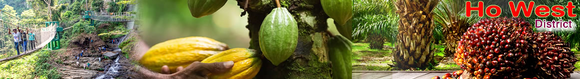
There are several soil types in the District. These are; Forest Soil which includes forest ochrosols, lethosols and intergrades soil found in the mountainous and wetter areas in the District.The forest soil supports perennial crops such as Cocoa, Oil Palm, Coffee, Avocado, Plantain and Banana while the Savanna Soil supports produce like; maize, cassava, yams, groundnuts, legumes and variety of vegetables.
Date Created : 11/29/2017 2:37:02 AM


- District Sublinks
- Other Links
- Other Officers
- Downloads
- Saboba: Compensation 2022

 facebook
 twitter
 Youtube
 TOLL FREE 0800 430 430
 +233 593 831 280
 GPS: GE-231-4383
 info@ghanadistricts.com
 Box GP1044, Accra, Ghana